Dimensional Model
Overview
The data warehouse follows the Kimball method designed as a star-schema dimensional model and organized into two data marts, one per data source, sharing conformed dimensions that enable cross-mart (enterprise) analysis.
| Mart | Fact Table | Grain |
|---|---|---|
| Mart 1: 311 Service Requests | Fact_311Service_Request |
One row per unique 311 service request |
| Mart 2: Traffic Volume Counts | Fact_Traffic_Count_15Min |
One row per 15-minute volume count at a specific location and direction |
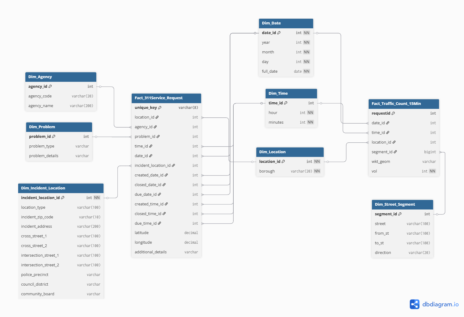
Model Diagram
The diagram below was generated from the DBML source file using dbdiagram.io. You can view and interact with the live diagram at the link below.
Conformed Dimensions
Three dimensions are shared (conformed) across both marts, enabling cross-mart joins for enterprise-level queries:
| Dimension | Key | Purpose |
|---|---|---|
Dim_Date |
date_id |
Calendar date (year, month, day, full_date) |
Dim_Time |
time_id |
Time-of-day (hour, minutes) |
Dim_Location |
location_id |
Borough-level geographic grouping |
Data Mart 1: 311 Service Requests
Grain: Each row is a unique 311 service request.
Fact Table: Fact_311Service_Request
| Column | Type | Constraint | Notes |
|---|---|---|---|
unique_key |
varchar(8) | PK | Source unique identifier |
location_id |
int | FK → Dim_Location | Borough |
agency_id |
int | FK → Dim_Agency | Responding agency |
problem_id |
int | FK → Dim_Problem | Complaint type |
time_id |
int | FK → Dim_Time | Time of original creation |
date_id |
int | FK → Dim_Date | Date of original creation |
incident_location_id |
int | FK → Dim_Incident_Location | Full address detail |
created_date_id |
int | FK → Dim_Date | Request created date |
closed_date_id |
int | FK → Dim_Date | Request closed date (nullable) |
due_date_id |
int | FK → Dim_Date | Request due date (nullable) |
created_time_id |
int | FK → Dim_Time | |
closed_time_id |
int | FK → Dim_Time | nullable |
due_time_id |
int | FK → Dim_Time | nullable |
latitude |
decimal | nullable | Point location |
longitude |
decimal | nullable | Point location |
additional_details |
varchar | nullable | Status / resolution notes |
Dimension Tables
Dim_Problem
Stores the complaint type and any sub-type details. Reduces cardinality vs. storing free-text directly on the fact table.
| Column | Type | Constraint |
|---|---|---|
problem_id |
int | PK |
problem_type |
varchar | e.g. “Street Condition”, “Street Light Condition” |
problem_details |
varchar | nullable sub-type |
Dim_Agency
| Column | Type |
|---|---|
agency_id |
int PK |
agency_code |
varchar(20) e.g. “DOT” |
agency_name |
varchar(200) full name |
Dim_Incident_Location
High-cardinality address data kept in a separate dimension to avoid bloating the fact table. Includes zip code (used in choropleth map analysis), cross streets, precinct, council district, and community board.
| Column | Type | Notes |
|---|---|---|
incident_location_id |
int PK | |
location_type |
varchar(100) | nullable |
incident_zip_code |
varchar(10) | used in zip-level analysis |
incident_address |
varchar(200) | high-cardinality; nullable |
cross_street_1/2 |
varchar(100) | |
intersection_street_1/2 |
varchar(100) | |
police_precinct |
varchar | |
council_district |
varchar | |
community_board |
varchar |
Data Mart 2: Traffic Volume Counts
Grain: Each row is a volume count for a specific 15-minute interval at a specific location and direction.
Fact Table: Fact_Traffic_Count_15Min
| Column | Type | Constraint | Notes |
|---|---|---|---|
requestid |
int | PK | DOT sensor request ID |
date_id |
int | FK → Dim_Date | |
time_id |
int | FK → Dim_Time | 15-min bucket |
location_id |
int | FK → Dim_Location | Borough (conformed) |
segment_id |
bigint | FK → Dim_Street_Segment | Road segment |
wkt_geom |
varchar | nullable | WKT geometry string |
vol |
int | NOT NULL | Vehicle count for interval |
Dimension Tables
Dim_Street_Segment
Captures the specific road segment where the sensor is located, including direction of travel.
| Column | Type |
|---|---|
segment_id |
int PK |
street |
varchar(100) |
from_st |
varchar(100) |
to_st |
varchar(100) |
direction |
varchar(20) e.g. “NB”, “SB” |
Design Decisions & Notes
Why separate Dim_Incident_Location from Dim_Location?
Dim_Location is a conformed, low-cardinality borough-level dimension shared with the traffic mart. Dim_Incident_Location holds high-cardinality address-level data specific to 311 requests, preventing fact table bloat and preserving the conformed dimension’s reusability.
Multiple date foreign keys on the fact table
Each 311 request has three relevant dates: created, closed, and due. Rather than using a single date dimension, three foreign keys point to the same Dim_Date table, a standard Kimball role-playing dimension pattern.
Known challenge: geographic join between marts
The 311 data provides borough + zip code, while the traffic data provides a road segment + WKT geometry. Cross-mart geographic joins are therefore at the borough level rather than street-segment level. This is noted as a limitation in the Conclusion section.
DBML Source
The full DBML source for this model is version-controlled in the project repository.